
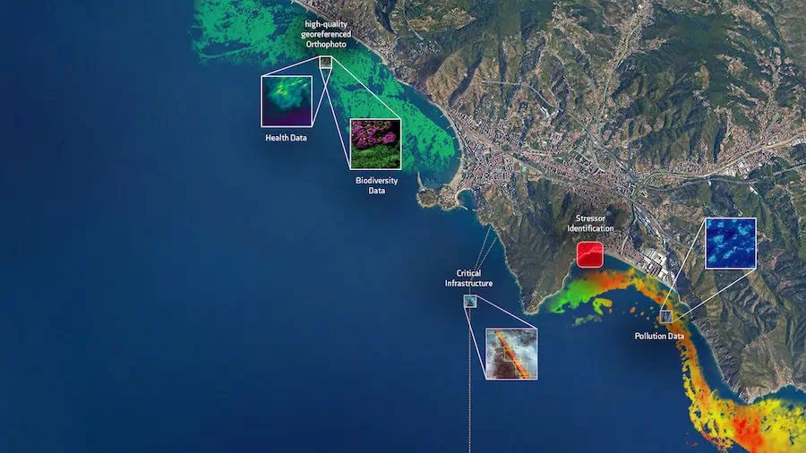

PlanBlue is a pioneering developer of state-of-the-art seafloor intelligence solutions that integrate underwater hyperspectral imaging (UHI), AI and geo-referencing to provide critical and actionable insights for enhanced and more efficient decision-making. This world-first technology automatically extracts key environmental metrics – including ecosystem health, biodiversity, biomass, and carbon stock – and identifies materials and anomalies such as oil residues, plastics, corrosion, and legacy seabed hazards.
Based on 16 years of cutting-edge development, our fully-automated technology can be easily deployed on board AUVs (autonomous underwater vehicles), ROVs (remotely operated vehicles) and USVs (uncrewed surface vessels), and is ideal for supporting a wide variety of use cases including security and defense, offshore infrastructures, and nature-based operations.

Our Technology
PlanBlue’s platform-agnostic payload integrates with AUVs, ROVs, USVs, towed systems, and diver-operated setups, providing a flexible solution that can be tailored to different use cases, scenarios, and operating conditions. The payload incorporates a UHI sensor, high-resolution RGB camera, environmental sensors, lights, computing unit, and motion and navigation units.
Our unmanned underwater survey technology can be provided in two form factors. Optimal surveys require an indicative 2-2.5 m altitude from the seafloor to reduce absorption of transmitted and received light.
AutoRay

Our adaptable sensor payload integrates seamlessly into a wide range of ROV and AUV platforms, allowing you to benefit from our technology while using your existing equipment. We can also provide deployment services through one of our trusted partners.
 This solution is ideal for large-scale projects, enabling high-speed, precise monitoring of extensive seafloor areas and efficiently delivering accurate results across vast distances. PlanBlue’s AutoRay relies on the motion-navigation of the carrier platform.
TowRay
 This plug-and-play solution is designed to be towed behind a vessel, and is ideal for mapping near-shore, shallow, or flat seafloor areas. The cost-effective solution is highly suitable for covering large areas, and provides the option to monitor real-time data acquisition.
TowRay requires a small vessel with a winch to regulate altitude from the seafloor, similar to other geophysical towing equipment.
Data Products
By providing the entire data chain, we deliver the world’s first highly detailed seafloor maps for a wide variety of underwater operations – standardized, fully automated, fast and at scale. Our software pipelines extract a wide range of data products from the same dataset in just hours, tailored to your specific needs and markets.

Examples of our data products include:
 Orthoimagery
We produce high-resolution, geo-referenced stitched maps of the seafloor with 1×1 mm accuracy, which serve as the foundation for our other data products. Our automated processes eliminate distortions caused by the water column, delivering crystal-clear results.
 Health
We can visualize the health of the seafloor with our hyperspectral data. Through a range of pre-determined indices, we can highlight the productivity of seagrass meadows through chlorophyll levels, or the health status of a coral reef.
 Ecosystem Stressors
We visualize ecosystem stressors by highlighting early indicator species. For example, using hyperspectral data we can detect microbial mats even before they become visible to the human eye or standard cameras.
 Biodiversity
We leverage hyperspectral data to provide significantly more information per pixel compared to standard RGB cameras. This enables us to identify a wide array of genera and species on the seafloor, including reef builders, indicator species, invasive species, and ecosystem engineers.
 Carbon Stock
We quantify the carbon stored in seafloor organisms such as seagrasses, based on their biomass, and can use this data to estimate the carbon content within the seafloor itself.
More information: Data Products
Applications
Maritime Security & Defense

Our seafloor intelligence technology empowers defense and security stakeholders with critical insights that enhance situational awareness, operational resilience, and national security. Ideal for protecting underwater infrastructure such as pipelines, communications, naval installations and structural foundations, as well as for detecting UXO (unexploded ordnance), our AI-powered analysis shortens data delivery from weeks to hours – providing a crucial strategic advantage in time-sensitive situations.
PlanBlue’s subsea mapping capabilities have been used to support a range of defense and security use cases, including:
Strategic Environmental Reconnaissance (SER) – by mapping physical, biological, and geological features, our hyperspectral imaging capabilities can be used to identify natural and artificial seafloor anomalies, assess terrain suitability, and characterize environmental conditions that could affect naval operations or underwater installations.
Infrastructure Installation & Surveillance Planning – our geo-referenced seabed mapping ensures precise placement of critical subsea infrastructure such as communications cables, sonar arrays, or surveillance platforms, reducing risk and eliminating guesswork.
Subsea Asset Protection & Integrity Monitoring – by detecting early signs of wear, disturbance, or sabotage, our technology provides a critical early-warning capability that ensures reliability and maintains operational security for subsea assets such as fiber optic lines, power cables, foundations, and detection systems.
Marine Domain Awareness (MDA) – our AI-driven data reanalysis enables detection of subtle ecosystem disruptions that may indicate illicit activities or covert threats such as trafficking, illegal dumping, and unauthorized installations.
In addition to high-accuracy data products, our processing pipeline provides comprehensive visual reporting that can be used to aid stakeholder communications and compliance documentation, as well as digitally traceable and fully auditable records.
Our efficient and autonomous survey operations reduce reliance on large vessels and extended field deployments, allowing you to reduce carbon footprints and environmental impact while aligning with sustainability goals.
Marine Ecosystem Protection & Restoration

Our solutions are ideal for protecting and restoring biodiversity and ecosystems at all depths, enhancing nature-based solutions such as artificial reefs, seagrass planting, and coral replanting. We offer a powerful MRV (monitoring, reporting, and verification) tool to track and validate the impact of these projects, ensuring measurable and transparent outcomes.
We provide a range of data deliverables that can be used to visualize the progress of projects while providing credibility by accurately measuring carbon capture and storage as well as biodiversity metrics.
These include:
- Seafloor health metrics such as chlorophyll levels in seagrass meadows
- Visualization of ecosystem stressors through highlighting of early indicator species such as microbial mats
- Hyperspectral biodiversity data and identification of seafloor organisms including reef builders, indicator species, invasive species, and ecosystem engineers
- Quantification of carbon stored in seafloor organisms based on biomass
- Measurement of biomass of the benthic substrate, based on parameters such as Leaf Area Index, shoot density, coverage and canopy height
- Percentage coverage of organisms and materials on the seafloor, including seagrass meadows and corals
These assessments will qualitatively improve seafloor habitat mapping, leading towards more insightful action for marine ecosystem protection and restoration.
Underwater Construction & Offshore Installations

Our biodiversity, physical and geological assessments are highly suited to developers and operators of offshore installations such as wind farms, providing non-invasive environmental insights for all possible projects including site selection, ongoing monitoring, maintenance, and decommissioning.
The autonomous and digitally-driven survey approach reduces reliance upon large fuel-intensive vessels, minimizing carbon footprints while providing the high-resolution georeferenced data required to undertake operations with confidence.
Benefits include:
- Reduce costs and project times thanks to enhanced efficiency and faster data analysis
- Minimize ecological impacts by identifying and avoiding sensitive locations or times of year
- PlanBlue’s technology can be applied as a robust MRV tool for nature-based projects aimed at enhancing or restoring biodiversity, such as artificial reefs, oyster reefs, and other marine ecosystems
The data acquired with our technology across all phases of an offshore facility’s lifecycle (pre-construction, operational, and decommissioning) enables comprehensive assessment of seafloor impacts. This makes it possible to identify where and how restoration should occur, driving measurable, nature-positive outcomes.
How We Work
Our approach to subsea mapping is faster, more efficient and more cost-effective compared to traditional methods that rely on divers and video-based analysis. Thanks to our innovative hyperspectral imaging technology, high-quality data products can be delivered at scale within an extremely rapid timeframe and with no observer bias.

Traditional mapping with spot sampling by divers

Seafloor mapping with PlanBlue technology
Our Technology, Your Benefits
Fast Time-to-Data
Through automation, we reduce analysis time from months or days to just hours, enabling rapid decision-making and reducing costs.
High-Quality Image Recording and Processing
We have overcome numerous technical challenges to deliver crystal-clear results, such as water-column correction and light modelling.
Objective Results
Our AI-driven annotation libraries accurately identify seafloor properties, minimizing the need for human intervention both in-field and during analysis, thus ensuring consistent and objective data.
Multidimensional Data
Our system collects data without the need for sub-sampling, ensuring that every recorded pixel contributes to delivering precise results tailored to your requirements.
Geo-Referenced Data for Precise Time-Series
Our underwater navigation sensors facilitate accurate site revisits, enhancing project credibility and transparency by reducing costs.
Multi-Level Quality Control
We ensure robust quality control in the field through map views, video playback, and live GPS tracking – helping to prevent redundancy and streamline workflows. Automatic backups and incremental data imports keep operations efficient and secure.
Our Business Model: Flexible, Collaborative, Effective
Technology on Lease
We provide our advanced underwater technology through a rental model, eliminating the need for large upfront investments and ensuring that you always have access to the latest innovations.
We Process, You Survey
Our partners and clients retain ownership of their surveys and fieldwork, while we handle the complex data processing and analysis. This division of roles leverages both your field expertise and our data intelligence capabilities.
Collaborative Value Creation
This model ensures that:
- You stay in control of your projects.
- We deliver actionable, high-quality insights from the data.
- Together, we achieve faster, more cost-efficient, and more reliable results.

Reviews
There are no reviews yet.